How Did Uluru Formed?
by John Dickens August 4, 2025
You’ve seen the photos. That massive, red monolith rising out of the desert like something from another planet. But Uluru isn’t just a photogenic backdrop for outback sunsets. It’s a geological epic — a sandstone survivor with more layers than your average onion, forged by ancient seas, earth-shaking tectonic tantrums, and a few hundred million years of erosion that’d put any sculptor to shame. So lets fiigure out how did Uluru form.
When I first stood before Uluru, I wasn’t just floored by its size — I was gobsmacked by how out of place it looked. Flat desert all around, then bam — this hulking great thing, smack in the middle of nowhere. But there’s a good reason for that, and it starts a looooong time ago.
Formation: A Rough Timeline (Because Rocks Don’t Rush)
Here’s the simplified dirt-on-the-rock version:
1. 550 Million Years Ago: Underwater Beginnings
Back then, central Australia was underwater — part of an inland sea. Around the edges of that sea, mighty mountain ranges (the Petermann Ranges) loomed. These ranges were tall, craggy and just begging to be weathered down. Rain and rivers carried bits of those eroding mountains — mostly sandstone and conglomerates — into alluvial fans around the basin’s edge.
This debris slowly built up and compacted into rock layers — layers of sand, mud, and gravel that hardened into sedimentary rock. What would eventually become Uluru is mostly arkose, a type of coarse sandstone rich in feldspar. Some call it arkosic sandstone, and it’s important — feldspar weathers easily, so Uluru’s not as tough as it looks. Originally sand, now stone.
2. 400 Million Years Ago: The Earth Folds Inward
During a massive tectonic event called the Alice Springs Orogeny, these sedimentary layers got compressed, folded, and tilted almost vertically. This is when Uluru stood on end, like a flipped-over sandwich.
That’s why today you see long vertical cracks and bedding lines running top to bottom — the original horizontal layers now stand up like toast soldiers.
3. The Long Erosion Game
Once uplifted, the softer rocks surrounding the monolith eroded over time — wind, water erosion, and temperature extremes did their slow magic. Uluru stood firm (ish), while the rest wore away. What was once buried became exposed. And over millions of years, nature sculpted the Uluru we see today.
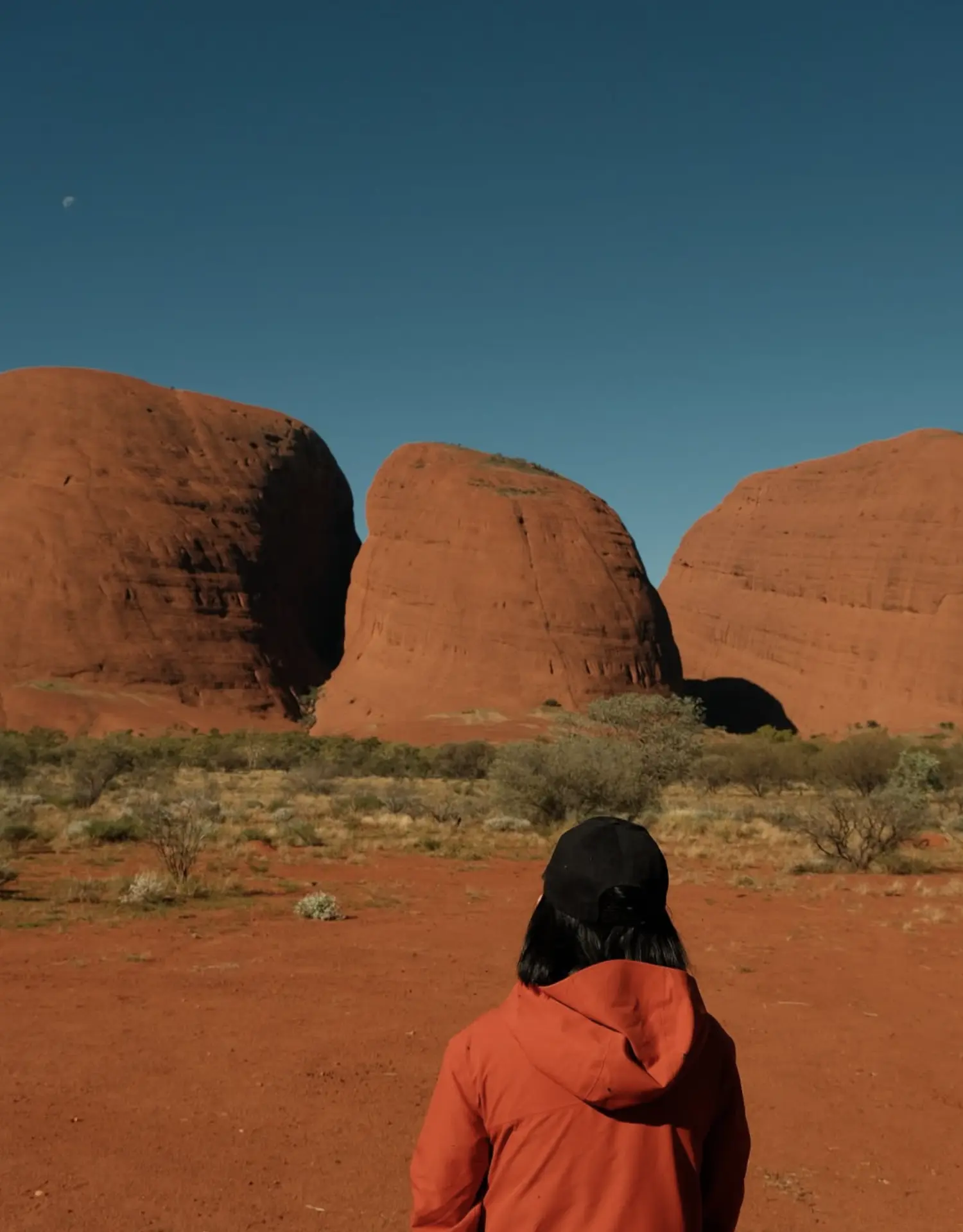
And here’s the kicker: Uluru isn’t alone. Kata Tjuta, those big domes 50km away, are made from similar deposits, just a different rock type — a mix of boulders and gravel cemented together called conglomerate. Different rock types, same wild history.
The Real Reason Behind Its Colour
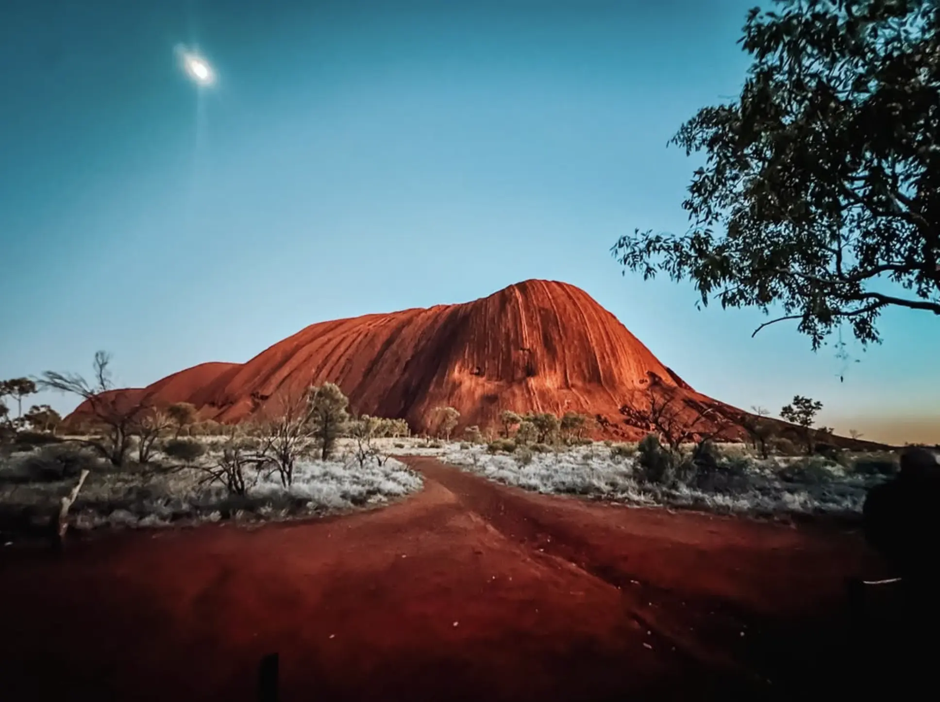
Ever wondered why Uluru’s colour is so famously rusty red? It’s not actually red on the inside. The arkose stone is greyish-pink when freshly broken. But the surface oxidises — think rust on old iron — creating a rich, reddish iron oxide layer.
You’ll notice the colour shifts dramatically with the light. At sunrise it glows apricot, then blood-orange by sunset, with deep purples in between if clouds play nice. It’s this colour morphing that makes sunset at Uluru feel almost sacred — and why it’s best seen with a cuppa (or cold tinnie) in hand.
Taller Than You Might Think
Here’s where things get cheeky. Above ground, Uluru rises 348 metres, taller than the Eiffel Tower. But what you see is just the tip. Most of Uluru’s bulk is buried underground, like a geological iceberg.
So no, it didn’t “rise” out of the ground like a giant molehill. What happened is that the land around it eroded away. Uluru stayed put, and everything else buggered off.
A Cultural Perspective
For decades, tourists traipsed up Uluru’s spine, despite clear signs asking them not to. Thankfully, the climb officially closed in 2019 — a huge win for Anangu Traditional Owners, who’ve always asked visitors to respect the rock’s spiritual and cultural significance.
For the Anangu, Uluru is a sacred site, tied to Tjukurpa (Dreaming Law). Certain sections of the rock are gender-specific and hold deep cultural meaning. When we walk there, we do it with permission — and respect.
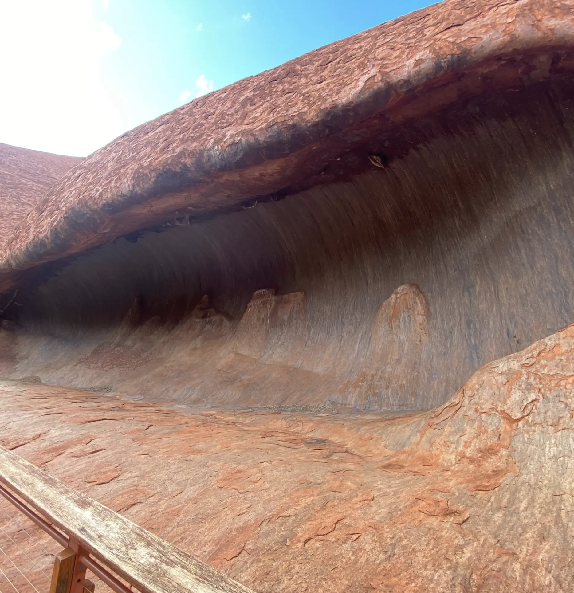
Instead of climbing, take the Uluru tour or Base Walk — a 10.6km track that loops the base. It’s flat, stunning, and full of interpretive signs explaining geology, plants, sacred sites, and creation stories. I recommend walking it early morning or late arvo to dodge the heat.
Planning Your Trip
Best Time to Visit:
- May to September (the dry season) offers cooler temps and clearer skies.
- Avoid summer unless you love 40°C days, mozzies, and heatstroke.
Getting There:
- By car: Alice Springs is a 5-hour drive. Make sure your spare tyre’s in good nick or book Uluru tour from Alice Springs.
- By air: You can fly into Ayers Rock Airport (Connellan) from major cities.
Park Pass:
- You’ll need a Parks Australia pass to enter Uluru-Kata Tjuta National Park. Book online to skip the faff. The park is jointly managed by the Traditional Landowners and the Australian Government.
Respect the Rules:
- No drones
- Stay on marked tracks
- Don’t photograph sacred sites (they’re signed)
- Leave no trace — pack out what you pack in
Facilities:
- Yulara is the nearby tourist facility town with accommodation, fuel, food, and guided 2-day Uluru Tour.
Watch Out For:
- Poisonous snakes — they’re shy but about
- Desert skink and other endemic plants and critters
- Exotic plant species — some introduced ones are invasive
- Mud after rain — tracks can get boggy after heavy rain
Fun Geological Facts (To Spruik at the Campsite)
- Uluru is made of arkose sandstone, not the more common quartz-rich sandstone
- Its layers tilt at about 85 degrees — nearly vertical
- The rock weathers differently on each side depending on sun and wind exposure
- The surrounding plain is called the Amadeus Basin, where all those sediments settled
Final Thought
Uluru isn’t just a stunning geological freak. It’s a living part of Aboriginal land, rich with cultural law, conservation significance, and meaning. When you visit, take the time to understand that story — the geological processes and the creation period shared by Indigenous Australians.
Some see rock — others see forms of people shaped in stone, stories etched in time. That’s the power of walking on Country.
And if you’ve got questions or reckon I missed a good rock yarn, drop it in the comments — I’m always keen for a chinwag over geology and billy tea.
FAQ
How was Uluru formed in simple terms?
It started as sand and rock debris washed from ancient mountains into a sea basin. Over time, this hardened into arkosic sandstones. Tectonic shifts later tilted it, and erosion exposed the monolith we see today.
Is Uluru still growing or changing?
Not really. It’s slowly eroding, especially during heavy rains, but not growing. It’s stable geologically.
Can you touch Uluru?
Yes — in non-sacred areas. The base walk lets you get up close, and some parts can be gently touched. Just be mindful of cultural signage and sacred sites, join one of the guided Uluru tours to have a respectfull trip.
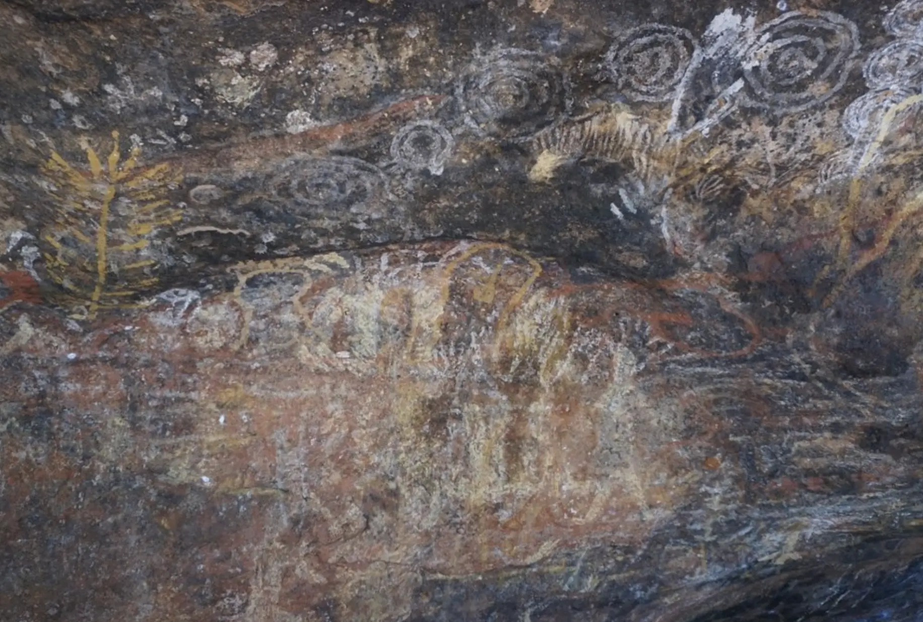
Are there caves or waterholes?
Yep. Around the base, you’ll find ancient rock art sites, waterholes, and caves used for shelter. Some have interpretive signs and guided tours from Alice Springs to Uluru. Look out for ancient paintings and carvings with deep cultural heritage.
Is Uluru connected to Kata Tjuta underground?
Great question — but no one’s drilled that deep! They formed from similar sediment deposits, but aren’t connected by a single rock body underground.